


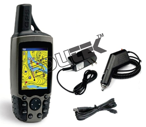
Global Positioning System
Product Details:
- Click to View more
-
Share Your Product:


X
Product Description
GLOBAL POSITIONING SYSTEM (GPS)It helps to track positions or locations. To survey position in a short period of time. Also used in mapping, surveying and area calculation.
Specification
- Receiver Hand held , WAAS enabled , high sensitivity SiRF or equivalent c h i p s e t w i t additional amplification external antenna connector
- External Antenna with 5m cable and connector compatible with the receiver
- Number of Channels:12
- GPS accuracy: < 5 meters, 95% typical
- WAAS accuracy: < 2 meters, 95% typical
- Display Color LCD, 256 x 400 resolution, wide screen 1.5X2.5
- Case: Fully gasket, high-impact plastic alloy, waterproof to IEC 529 IPX7 standards
- Temperature range: -15° C to 70° C
- Power Required : Two sets of 35 hours (minimum) rechargeable batteries including appropriate battery charger unit
- Memory Greater than 256MB internal memory and Has to accept a great deal of a memory micro SD card (8GB) for loading detailed topographic, level maps or additional way points into the receiver
- Waypoint 1000 waypoints
- Interface USB to PC that enables to quickly load maps and waypoints on device, interfacing cable and appropriate software
- Features: Breakout Board available, Waterproof: water-resistant ,electronic compass, barometer/altimeter, Geocaching, Preloaded detailed maps included and accept custom maps .
- Documentation User manual
- Warranty : One year
- Configuration Configured , tested and commissioned
- Training User training given by.
Tell us about your requirement

Price:
Quantity
Select Unit
- 50
- 100
- 200
- 250
- 500
- 1000+
Additional detail
+91
Email

Other Products in 'Agricultural Moisture Meter' category
"We deal all over World but our main domestic market is South India"

- EDUTEK INSTRUMENTATION
GST : 06AEWPJ6896D1ZU - Factory: 70, Edutek House, Main Road Vikaspuri, Industrial Area, Ambala Cantt - 133006, Haryana, India
- Phone :07313726362

- Email Id : edutekgroup@gmail.com
- Mr Aditya Kumar (Director-International Sales)
- Mobile :07313726362
- edutekgroup@gmail.com
 |
EDUTEK INSTRUMENTATION
All Rights Reserved.(Terms of Use) Developed and Managed by Infocom Network Private Limited. |
